Atlas synthesis
BIOLOGICAL MONITORING AND QUALITY OF MEDITERRANEAN WATERS
In order to gain a better understanding of all the information acquired by these monitoring systems (RECOR, TEMPO, PISCIS, CALME, SURFSTAT and IMPACT), an initial compilation and synthesis of this data has been published in a biological monitoring map atlas.
Published by Andromède Océanologie and the RMC Water Agency in 2020, this cartographic atlas of Mediterranean coastal water quality presents the results of biological monitoring, including the ecological status of Posidonia meadows and coralligenous reefs, their ecological functions and the level of pressure exerted. It is based on the European reference framework for defining quality objectives for coastal water bodies, as set out in the Water Framework Directive.
For each body of water, the information acquired by the biological monitoring systems is presented in its synthetic and individual form, but also through a triplet of qualification “ecological status, status of ecological functioning, level of pressure”. This triplet is used to qualify each body of water. It provides a general assessment of the state of health of seagrass beds and coralligenous. This first atlas, published in 2020, is based on 430 biological data acquired over the period 2014-2019 and on 11 anthropogenic pressures.
In 2024, the atlas will be updated using the most recent monitoring data (2020-2023). New bioacoustic and fish functional diversity indicators, based on bibliography and expert proposals in the light of current knowledge, will be added to the qualification triplet (state of ecological functioning). Certain quality grids have also been updated in line with new data and improved knowledge. Finally, two new pressures have been added to the pressure level, bringing the total number of anthropogenic pressures to 13. A total of 426 biological data are summarized for the French Mediterranean in this atlas, in order to assess the ecological status and the state of ecological functioning of these ecosystems. They come from 173 study stations for Posidonia meadows and 253 study stations for coralligenous reefs.
These data from the 2020 and 2024 atlases have been interpreted and summarized in 83 maps, which can be accessed on the MEDTRIX platform (Atlas project).
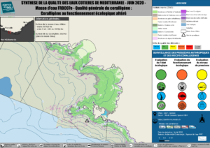
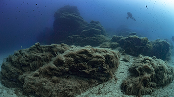
Final state of coralligenous in water body FRDC07e (atlas, 2024)
Coastal water monitoring is a constantly evolving and iterative process, designed to assess the state of the water. This summary work enables us to establish a new diagnosis of the monitoring of each body of water. It is also used to assess the effectiveness of the corrective measures required to achieve good status in the Mediterranean.
Contacts : Gwenaëlle Delaruelle ( gwenaelle.delaruelle@andromede-ocean.com ) & Pierre Boissery ( pierre.boissery@eaurmc.fr ).
Project leaders : Andromède Océanologique – Agence de l’eau Rhône Méditerranée et Corse
Data source : Andromède Océanologie, Agence de l’eau Rhône Méditerranée et Corse
Update frequency : 3 à 6 ans.
Partners : Agence de l’eau Rhône Méditerranée et Corse.