EVOLUTION AND MANAGEMENT OF ESSENTIAL MEDITERRANEAN FISH HABITATS
Essential fish (Teleost) habitats of coastal shallows: mapping, availability, and consideration in zoning for management measures.
Background :
Marine habitats provide a variety of essential functions for fish: feeding areas, spawning grounds or nurseries for juvenile stages. In the underwater landscape mosaic, these functions are provided by various habitats, thus complementary, different according to the species (Harmelin-Vivien et al., 1995; Garcia-Rubies and Macpherson, 1995; Cheminée et al, 2021). In addition to managing adult removals, it is therefore necessary to preserve these habitats that are essential to the life cycle of the species.
From the perspective of judicious prioritization of conservation objectives, it is therefore necessary to better understand the role and distribution of these key habitats, spawning grounds and nurseries. This is the context of the MedHab project (2019-2022): it aims to locate and quantify the availability of certain marine habitats fulfilling an essential nursery function. This project, financed under the 2018 call for research projects led by the DIRM (Direction Interrégionale de la Mer), is one of the concretizations of the PAMM (action plan for the marine environment) Mediterranean. The PAMM itself represents a variation of the DCSMM (Framework Directive Strategy for the Marine Environment) aimed at achieving or maintaining good environmental status of marine environments.
Methodology :
The Medhab project is structured in different packages:
WP1: To gather and analyze the data available in the literature about Teleost nursery and spawning habitats.
WP2: On the whole coastline, locate and quantify sparid nursery habitats (small heterogeneous bottoms) and evaluate their current management. Carry out field verifications of this mapping, including a census of juvenile populations. In addition, in three study areas (Provence, French Catalonia, NW Corsica), to estimate the relative availability and recruitment potential of this habitat with respect to two other types of nursery habitats (Posidonia meadow and infralittoral rock).
WP3: To ensure a transfer of skills and acquired knowledge to the managers by the realization of online databases, training, and to raise awareness among the general public.
Concerning the method used, the scope of the study extends to the entire French Mediterranean coast, including Corsica, i.e. 2,705 km of coastline.
Mapping:
Nurseries were identified by visual recognition on satellite images. To do this, the Google earth (https://www.google.fr/intl/fr/earth/index.html), Google Maps (https://maps.google.fr/) and Geoportal (https://www.geoportail.gouv.fr/) platforms were used. The portions of the coastal line that meet the four criteria defining the small heterogeneous bottoms (SLB) (depth, slope, substrate and hydrodynamics) were identified as nursery habitat (Harmelin-Vivien et al., 1995) and plotted in Qgis as a line vector overlaid on the coastline. This habitat right-of-way plot was drawn at a constant scale (1/1000) to avoid scale effects (fractals) and thus ensure a consistent method and assessment across sites.
Ground truth:
Depending on the configuration of the coast, the homogeneity of the substrate, the quality of the photos and the hydrodi3namic condi3ons during the shooting, the identification of nurseries on satellite images can be difficult. The mapped habitats are therefore potential nurseries and a ground truth operation (included annually in the MedHab project) was orchestrated to verify in situ the reliability of the identification via satellite images, an essential step for the validation of the method (Cheminée et al., 2014; Cuadros et al., 2018).
Two types of ground truth were implemented:
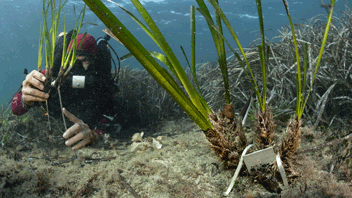
– (1) During the summers of 2019 and 2020, a ground truthing was carried out on some randomly selected nurseries: these were respectively 11, 17, 17 and 19 sites mapped as PFH nurseries in four pilot study areas (Côte Bleue, Calanques, Calvi and Scandola). It consisted of an in situ observation of the habitat characteristics on the sections mapped as potential nurseries, in order to verify the adequacy of the 4 ecological criteria defined above. If necessary, the mapping was rectified afterwards. In addition, this ground truth was used to carry out a census of juveniles in the sections validated as nurseries (Cheminée et al., 2017, 2011). This step allowed to validate in situ the cartography resulting from the GIS, but also to enrich the study with a follow-up of the juvenile densities allowing to estimate the nursery value of the surveyed sites.
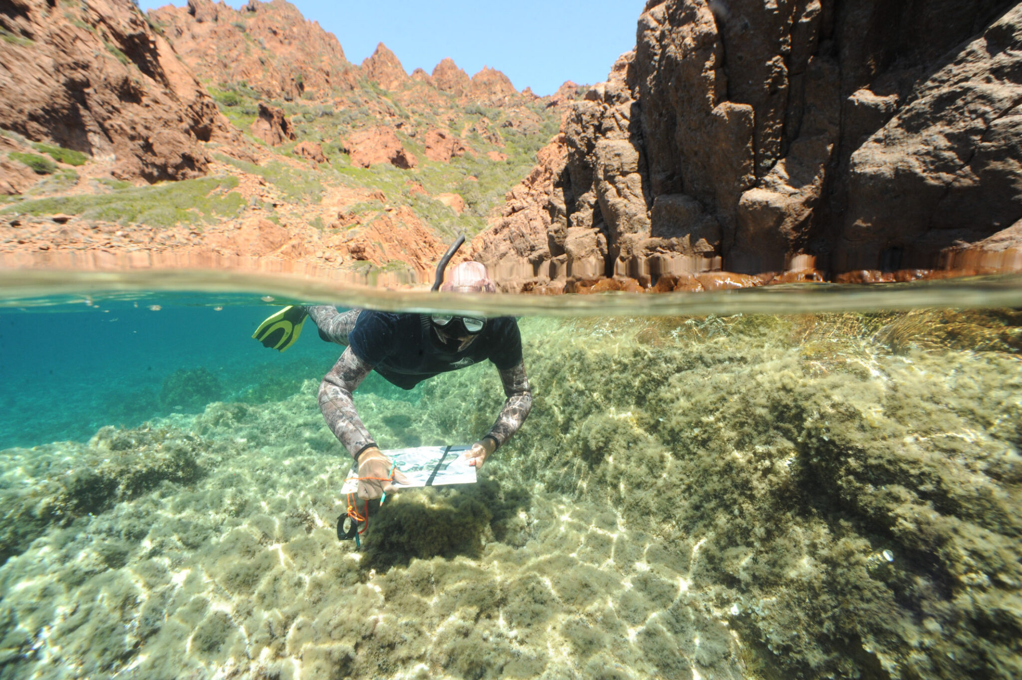
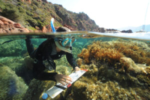
– (2) In addition, during the summer of 2020, at Scandola, an experiment allowed us to estimate the accuracy of the cartographic identification of PFH nurseries via satellite images. Four randomly selected stretches of coastline, totaling 6.3 km of coastal line, were surveyed with mask-tuba fins (PMT) in order to visually locate in-situ and map with a GPS the PFH nursery habitat. Each PMT operator did this blindly, i.e. without prior knowledge of the mapping done via GIS. A posteriori, the superposition and comparison of the two maps (the one from the in situ surveys versus the one made via analysis of satellite images) allowed us to estimate the percentage of error of the identification method on satellite images.
Results and descriptors available on MEDTRIX :
In 2019, 2020 and 2021 these mapping and ground-truth campaigns allowed the validation of the method of mapping heterogeneous shallows via satellite imagery. These field campaigns also allowed the characterization of juvenile assemblages. This was carried out in three pilot areas in Provence, Corsica and Occitania, including the Calanques National Park, the Côte Bleue Marine Park, the Scandola Nature Reserve, the Gulf of Calvi, the Cerbère Banyuls Marine Nature Reserve and the Gulf of Lion Marine Nature Park. Over the whole area, 4989 PFH nurseries were identified and mapped. These nurseries, with an average individual length of 51 (± 42) m, total nearly 254 km. Their overall availability at the scale of the coastline was thus estimated at 9.39% of the coastal line.
The results of the ground truthing operations also allowed us to confirm the reliability of these results. Indeed, the comparison between the mapping carried out in-situ in PMT and the mapping via satellite image showed an error rate of +1.44 (± 5) % for the latter. The mapping of PFH nurseries on the entire French Mediterranean coastline thus allowed us to estimate the average availability of PFH nursery habitat at 9.39% of the coastal line. This finding of the scarcity of this habitat along the entire French Mediterranean coastline confirms the punctual results of previous studies on PFH habitat, whether in localized studies on sectors of the northwestern Mediterranean (Cheminée et al., 2014, 2011; Pastor et al., 2016), on island coastlines, such as Menorca in the Balearic Islands (Cuadros, 2015), or in other countries around the Mediterranean (Ezagouri-Lara, 2016).
The mapping thus carried out provides a location of PFH nursery habitats. The proportion of error in the photo-identification of nurseries via satellite images (due to the configuration of the coastline, the granulometry of the substrate, the quality of the photos and the hydrodynamic conditions during the shooting) could be estimated during our field survey: these errors (minimal) concerned stretches of coastline qualified as favorable for juveniles when in reality they were too steep, the substrate too homogeneous (e.g. smooth rock), or exposed to too much hydrodynamic action.
Thus, overall, PFHs represent a small proportion of the linear compared to other nursery habitats (Cuadros, 2015) and do not form large homogeneous areas but numerous short stretches of coastline. These two characteristics – low availability and small size – make it a habitat that is all the more vulnerable to habitat transformations induced by coastal artificialization.
Contact : Adrien Cheminée adrien.cheminee@septentrion-env.com et Justine Richaume justine.richaume@septentrion-env.com
Project leader : Septentrion Environnement, http://septentrion-env.com
Partners : Le projet bénéficie d’un soutien financier de la part de : l’Agence de l’Eau Rhône Méditerranée Corse (AERMC), la Région SUD-PACA, la Région Occitanie, et la DIRM.
Les partenaires techniques sont : Parc National des Calanques, Parc Marin de la Côte Bleue, STARESO, PNR Corse et RN Scandola, Parc Naturel Marin du Golfe du Lion et Réserve Naturelle Marine de Cerbère-Banyuls