Monitoring of Natural Fishery Resources by Acoustics
The SIRENHA monitoring system was set up within the framework of the monitoring of coastal fish populations in coastal water bodies and is based on a new fisheries monitoring protocol. Based on a surface approach resulting from the collection of linear information along the shipping lanes and the determination of a surface indicator, it completes the punctual approaches (underwater counts or videos, eDNA or passive acoustics). This device is part of a larger cooperation for the monitoring of coastal fish populations, involving in particular the Rhone-Mediterranean and Corsica Water Agency. The principle of the protocol using a single-beam echosounder is as follows:
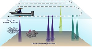
Figure 1: Use of active acoustics in the acquisition method of the SIRENHA project. Illustration of the principle of the SIRENHA protocol using a single-beam echosounder
A vessel moves along predefined trajectories that spatially sample the area to be monitored (reference area: 250 ha). The single-beam echosounder installed under the vessel acquires acoustic data in the water column, which are post-processed in an automated manner and result in a mapping of the “fish” surface indicator called ISPRE-MED (Indicateur Surfacique de PRésence de poissons de pleine Eau de MEDiterranée), which is calculated on a 50 m square grid. The indicator is defined per standard surface unit as follows
Number of detections
ISPRE-MED = ————————————– (per unit area)
Total number of pings emitted
A ping is an acoustic “shot”.
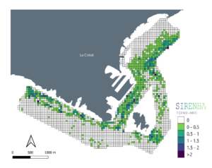
Figure 2: Cartographic representation of the ISPRE-MED indicator. The ISPRE value is displayed in a range of colors, on a 50 m square mesh. White indicates no detections, while a gradient from green to indigo blue corresponds to a higher number of detections. The darker and more blue the color, the greater the number of detections.
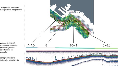
Figure 3: Visualization of an echogram and corresponding ISPRE value. Top: Cartographic representation of the ISPRE results on a sub-sector of the La Ciotat test site: a particular radial is ”framed”. Bottom: Echogram relative to this radial: this radial successively explores places presenting different densities of fish and thus values of the ISPRE. This one varies from 1/1.5 to 0 at the beginning of the radial, then passing from 0.5/1 to 0/0.5.
The monitoring strategy of the SIRENHA network is based on three components:
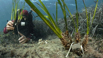
- The first is based on the exploitation of opportunity data collected regularly during studies carried out by the project owner (seasonal period: spring) and specifically on a set of sites spread over the coastline, presenting a wide range of typologies of pressures suffered by the environment (small marina, anchorage area, reference area, urban discharge, seaport and military…).
- The second is part of the three-year WFD campaign carried out by Ifremer on behalf of the Water Agency, using data collected along the entire Mediterranean coastline,
- The third consists in monitoring annually 3 sites representative of coastal water bodies, coastal habitats and pressures, which are La Ciotat, Cap Sicié and Théoules.
By clicking on the button “Access to the maps” you will find more details about the Sirenha project, in particular the acquisition of data to calculate the ISPRE (Indicateur Surfacique de PRésence de poissons de pleine Eau de MEDiterranée). You will also find the project brochure by clicking on the “Brochure” button, just below.
Contact : Claire NOEL, noel@semantic-ts.fr
Project leader : SEMANTIC TS, https://www.semantic-ts.fr/
Update frequency : Annuelle
Partners : Agence de l’Eau Rhône Méditerranée et Corse, Ifremer pour la campagne DCE
Related scientific publications