SCIENTIFIC EXPEDITIONS – PRESENTATION OF THE RESULTS OF DIFFERENT EXPEDITIONS
-GOMBESSA 5-
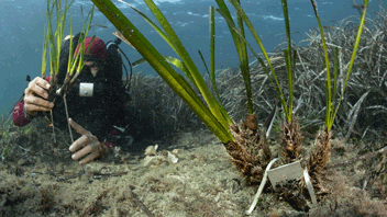
In July 2019, the Gombessa team achieved a world first by combining autonomous rebreather diving with saturation diving initially dedicated to offshore operations. The four divers of the “Gombessa 5 : Mediterranean Planet” mission lived, confined, in a pressurized bathyal station to crisscross the Mediterranean coast between Marseille and Monaco and initiate an innovative approach to evaluating the biodiversity and state of the waters of the twilight zone.
The « Gombessa 5 : Planète Méditerranée » itinerant mission brings together the three values of the Gombessa expeditions : a diving challenge to be met, a scientific mystery to be solved, and a promise of images to be brought back.
The divers lived together for 28 days in a 5 m² module pressurized to 13 bars, the equivalent of -120 m of water.

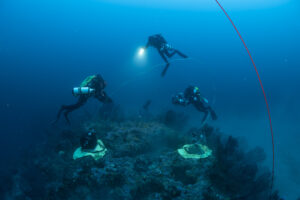
Gombessa 5 team, @Laurent Ballesta, Andromède Océanologie.

Diagram of the bathyal station ©Laurent Ballesta, Andromède Océanologie, GOMBESSA 5
Through 31 dives, they spent 75 hours each studying the ecosystems between -65 and -142 m depth by carrying out transdisciplinary scientific protocols established with 17 partners from various French and foreign research organizations.
Equipe de Gombessa V ©Laurent Ballesta, Andromède Océanologie, GOMBESSA 5
The main objectives of the expedition are the following :
1 – To map deep rocky habitats (coralligenous reefs, offshore rocks) through bathymetric acquisitions in order to complete the continuous mapping of marine biocenoses available on DONIA Expert and to precisely locate the areas of interest to be explored for the expedition.
2 – To carry out an exploration mission on the state of the twilight zone, focusing on its chemical and ecological quality.
Different protocols were thus set up in order to :
– Carry out temperature profiles
– Inventory and illustrate new species never photographed in their lifetime or in the natural environment ;
– Inventory and illustrate the deep underwater landscapes and species of the mesophotic zone in video and 2D photos ;
– Illustrate the deep underwater landscapes in 3D by the photogrammetry method ;
– To understand the role of the coralligenous in the dynamics of climate change by evaluating the gas fluxes on two sites ;
– Understanding the functioning (abundance, connectivity) of rare species populations (kelp and black coral in the Mediterranean) using population genetics techniques ;
– Inventory the biodiversity (abundance, species of fauna and flora) of deep rocky areas, coralligenous and soft bottom by acoustics, environmental DNA, sediment samples, videos and photos ;
– To define the level of chemical and organic contamination of sediments ;
– Characterize the pollution by macro-waste (bottles, bags, …) and remains of uses on the bottom ;
– Characterize the deep sound pollution of a site (anthropophony) and understand the links between 3D spatial structure of the coralligenous habitat, biodiversity, sound of biological origin (biophony) and human activities ;
– Study the nutritional status and the associated microbiota of five species of deep-sea gorgonians.
Bathyal Station @Laurent Ballesta, Andromède Océanologie, Gombessa 5.
These different protocols can be grouped into seven categories illustrated on the following figure : diver physiology, temperature/conductivity, benthic chambers, biodiversity (biology, eDNA, genetics), species images and landscapes, sediments (chemistry and macrofauna), 3D and sound, macro-waste.
For more details on the different partners and scientific protocols as well as on the different scientific expeditions, please visit the GOMBESSA Expéditions website. You can also consult the special edition of the monitoring booklet HERE.
You can find the official video of the feature film HERE, directly on the “Gombessa Expeditions” YouTube channel, as well as all the Vlogs.
An opaque benthic chamber (left) and a transparent one (right) are placed on a coralligenous mass to measure gas exchange ©Laurent Ballesta – Andromède Océanologie
By clicking on the “Access to maps” button, the user will find the different sites explored, he will then be able to access the characteristics of the site, visualize the different protocols carried out and download the result sheets, through the display of a POP-UP window. He will also have access to the cartographic layers presenting the different protocols carried out.
Contact : Gwenaëlle Delaruelle –
Project Leader : Andromède Océanologie – andromede-ocean , Expéditions Gombessa – https://gombessa-expeditions.com/
Data source : Andromède Océanologie, Agence de l’eau Rhône Méditerranée et Corse (+ scientific partners of the Gombessa 5 expedition)
Update frequency : Not updated.
-COVID MISSION, eREF-
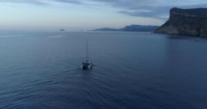
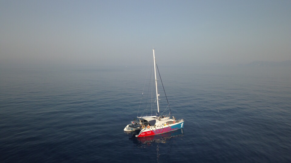
Catamaran Zembra during the April-May 2020 field mission
In April 2020, a scientific mission was carried out in the coastal waters of the French Mediterranean in order to reference and study, through environmental DNA (eDNA) sampling and bioacoustic measurements, the baseline state of biodiversity in marine vertebrates and invertebrates.
This spring of 2020 has indeed offered exceptional conditions in connection with the coronavirus pandemic and the first containment of the population. The human frequentation of the coast was at a minimum level that had never had an equivalent in the industrial era because tourist and sports activities were prohibited, even on the beaches, and fishing activity, especially artisanal, was greatly reduced.

No human traffic during the 1st confinement. @Andromede Oceanology
To better evaluate these impacts we need :
- Biodiversity sampling methods that are non-invasive, standard, non-destructive, exhaustive (rare or stealthy species) and inexpensive. The method of searching for DNA traces in the environment developed by the company SPYGEN is non-invasive (water sampling) and exhaustive (it targets all the species of a given taxonomic group) and makes it possible to improve the monitoring of rare or discreet species, and the monitoring of target species.
- Indicators of the state of pressure or restoration of the sampled environment.
- Conditions, therefore reference values for these indicators in order to know their range of variation and to be able to set management objectives to be reached on the state of the environment.

Sampling sites of the COVID mission (eREF), @Andromède Océanologie
We took advantage of this unprecedented situation to bring together marine biologists and academics with the following objectives :
- To survey vertebrate diversity by environmental DNA by conducting water filtration sampling to explore vertebrate biodiversity (bony and cartilaginous fishes, and marine mammals) under containment or early human population deconfinement.
- Complete the baseline for Mediterranean marine vertebrates on the 12S part of the genome to better assign environmental DNA fragments to species.
- Survey the diversity of invertebrates and vertebrates by acoustic measurements by placing hydrophones to assess Biophony (describe the ambient noise level) on the same reference stations as the environmental DNA.
- Develop, assess baseline status and test indicators of the health status of coastal water bodies.
- Develop a methodological guide for eDNA methods and indicator calculations.
- Correlate the eDNA and acoustic indicators of marine biodiversity with other monitoring data (temperature, biological, anthropogenic pressures, etc.).
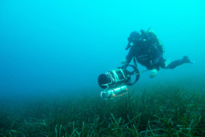
Waterproof DNA pump attached to a diver’s scooter for sampling. @Andromède Océanologie.
The eREF project will integrate in 2022 the location of all the study sites and the results of the eDNA / acoustic indicators. These sites are distributed along a gradient of human impact, with both anthropized sites (ports), Marine Protected Areas (MPAs), reference stations from existing monitoring networks, and the mesophotic zone.
More specifically, this study conducted in spring 2020 sampled 84 environmental DNA sites and 51 acoustic measurement sites :
– Six MPAs (Banyuls, Carry le Rouet, Calanques, Porquerolles, Cap-Roux, Calvi reserves) ;
– Two sites located in the mesophotic zone (Beach Rocks, Cap Lardier) ;
– 31 sites located in seagrass beds (reference stations from the TEMPO network), including 22 sites for acoustics and 25 for eDNA ;
– 37 sites located in coralligenous reefs (reference stations from the RECOR network), including 28 sites for acoustics and 31 for eDNA ;
– One site in a harbour at a biohut (RESPIRE) ;
– One site on an artificial reef (REXCOR).
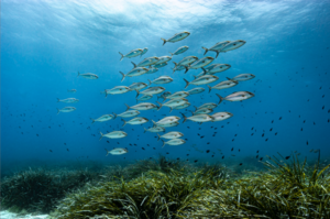
Posidonia seagrass bed, did the cessation of human activities during containment result in an increase in underwater life? ©Laurent Ballesta, Andromède océanologie – Gombessa 5.
The values of the indicators from the analysis of eDNA data for the year 2020 will be compared to those of the years 2018 and 2019 for which we have eDNA monitoring on this Mediterranean coastline both in MPAs and at different depths as part of the scientific expedition Gombessa 5.
You will soon find online on the Medtrix platform all the results of the expedition. In the meantime, you will find a series of 10 video blogs (3 and/or 4 minutes) on the scientific activities of the expedition. You will find them HERE.
Contact : Gwenaëlle Delaruelle –
Project leader : Andromède Océanologie – andromede-ocean , Expéditions Gombessa – https://gombessa-expeditions.com/
Data source : Andromède Océanologie, L’Agence de l’eau Rhône Méditerranée Corse, le laboratoire SPYGEN, CHORUS, l’URM MARBEC ET l’Université de Montpellier.
Update frequency : Pas d’actualisation.
Partners :Agence de l’eau Rhône Méditerranée et Corse, SPYGEN, CHORUS, Marbec, Université de Montpellier, Fondation Prince Albert II de Monaco, BLANCPAIN, Andromède Océanologie.
-GOMBESSA 6-
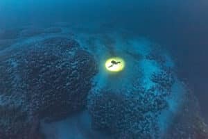
The 6th Gombessa scientific expedition supported by Andromède océanologie took place from July 1 to 20, 2021. As with “Gombessa 5 – Mediterranean Planet”, four divers used a combination of autonomous rebreather diving and saturation diving to explore the mesophotic zone. Between -110 and -140 m, they carried out various scientific protocols during 245 hours of diving to unravel a new mystery: the presence of thousands of perfectly circular rings 20 m in diameter.
These formations, discovered during campaigns carried out from 2011 to 2014 (CapCoral, CoralCorse and MedAtolls) to the north-east of Cap Corse, consist of a central coralligenous core and a crown of rhodoliths. They appear to be unique in the world outside this 4 km² zone located in the Cap Corse and Agriate Marine Natural Park.
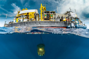
The barge and the submerged turret – ©Jordi Chias Gombessa Expeditions
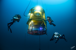
Supported by Andromède Océanologie, the Gombessa 6 expedition continued for the next two years (2022, 2023), focusing on the deep marine habitats of Cap Corse, including rings, coralligenous reefs, sea caves and kelp. These missions have enabled us to increase our knowledge of these deepwater habitats and their habitats. To achieve this, scientific protocols were set up during 692 hours of immersion, in partnership with some forty French and foreign researchers. Various scientific tools were mobilized, including acquisitions from ships and a surface drone, as well as deep rebreather dives and immersions by two exploration submarines and remotely operated underwater vehicles (ROVs).
From July 26 to August 6, 2022, from Andromède Océanologie’s trimaran – the Victoria IV, eight autonomous divers explored 11 undersea sites and their little-known ecosystems. The divers made 15 dives and spent a total of 302 hours underwater. The sites studied were located between -37 and -115 m around Cap Corse.
From July 13 to August 13, 2023, from the Victoria IV, the French Navy chartered tug – Pionnier, and the submarine support vessel – U-BOAT Navigator, 16 sites were explored by scuba diving for a cumulative 298 h 47 min underwater between 38 and 130 m depth, 12 sites were covered by submarine, totaling 32 h 13 min of exploration between 10 and 141 m depth and 11 sites were visited by ROV, totaling 8 h 53 min of exploration between 112 and 135 m depth.
Thanks to these 937 hours of immersion and the implementation of 37 different scientific protocols, the Gombessa 6 (2021) and Gombessa 6+ (2022-2023) expeditions have shown that Cape Corsica is home to a unique underwater landscape, the result of a particular geological history, and a thriving associated biodiversity that is exceptional for such depths.
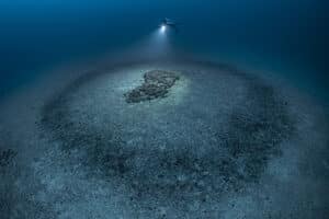
Coralligenous rings and deep coralligenous reefs ©Laurent Ballesta, Andromède océanologie – Gombessa 6.
Contact : Julie Deter –
Project leader : Andromède Océanologie – andromede-ocean , Expéditions Gombessa – https://gombessa-expeditions.com/
Data source : Andromède Océanologie, L’Agence de l’eau Rhône Méditerranée Corse ( + tous les partenaires scientifiques de l’Expédition).
Update frequency : Pas d’actualisation.
Associated scientific publications
- Les données de température acquises lors de la Mission Gombessa 5 (Juillet 2019) sont publiées et disponibles : Deter et al., 2020. Gombessa 5 cruise: CTD profiles in western Mediterranean, July 2019. SEANOE. https://doi.org/10.17882/71814
- Les données de température acquises lors de la Mission Gombessa 6 (Juillet 2021) sont publiées et disponibles : Julie Deter, Florian Holon, David Mouillot, Régis Hocdé (2021). Gombessa 6 “Cap Corse” cruise: CTD profiles in Corsica, NW Mediterranean sea, July 2021. SEANOE. https://doi.org/10.17882/89637
- Prioux, C., Ferrier-Pages, C., Deter, J., Tignat-Perrier, R., Guilbert, A., Ballesta, L., … & van de Water, J. A. J. M. (2024). Insights into the occurrence of phylosymbiosis and co-phylogeny in the holobionts of octocorals from the Mediterranean Sea and Red Sea. Animal Microbiome, 6(1), 62.