MAPPING OF HABITATS IN LAGOON ENVIRONMENTS
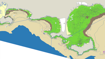
This project aims to define a typology adapted to the context of Mediterranean lagoons and to establish a first habitat mapping within French Mediterranean lagoons that will take into account their temporal and spatial variability. On the basis of physical, chemical and biological data collected in 36 lagoons since the year 2000, a unique and homogeneous habitat classification has been developed for the first time. It is based on six hierarchical levels : salinity, substrate, light availability, hydrodynamics, trophic status and biology. This habitat mapping (scale 1 :100,000) highlights the mosaic of existing habitats within lagoon ecosystems that have been considered relatively homogeneous until now. The structural definition of these habitats constitutes a first step towards the definition of functional habitats for the organisms living in these lagoons.
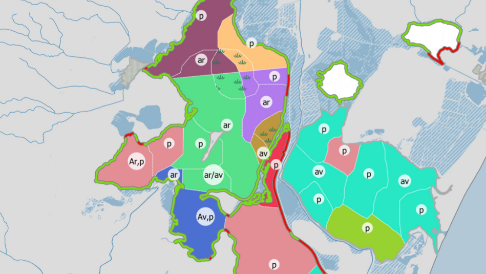
You can click on the “Access to the maps” button below to access the habitat map of the lagoon(s) concerned and a representation of the data by criteria.
The habitat symbology separates the abiotic criteria from the biotic criteria in order to quickly locate the homogeneous sectors from a physico-chemical point of view and the macrophytes. We distinguish :
- on the one hand, a colored figure integrates the criteria 1a salinity), 2 (substrate), 3 (light), 4 (hydrodynamics) and 5 (trophic state). This corresponds to typological level 5 after excluding criterion 1b (salinity variation) represented independently by hatching. In the legend, each of the criteria 1a to 5 are identified by their respective codes, the reading of which is facilitated by the grid below (the classes highlighted in grey being present on the map).
- On the other hand, criterion 6 Biology is immediately identifiable via a label indicating the dominant group in case of majority vegetation, or a vegetation figure in case of sparse vegetation. The absence of information indicates the presence of a bare substrate.
Contacts : Anaïs Giraud (anais.giraud@eaurmc.fr) / Vincent Ouisse (vincent.ouisse@ifremer.fr)
Project Leader : AERMC – https://www.eaurmc.fr ; Ifremer – https://wwz.ifremer.fr
Update frequency : Every 3 to 6 years
Partners : Rhone Mediterranean and Corsica Water Agency
Study reports

- Ouisse Vincent, Miramont Arthur, Bajjouk Touria, Cimiterra Nicolas, Derolez Valerie, Fontes Hugo, Giraud Anais, Vaz Sandrine (2023). Description méthodologique et analyse de la distribution des habitats en milieu lagunaire méditerrannéen. Projet CHAMILA (Cartographie des HAbitats en MIlieu LAgunaire mediterranéen) – Partie 1. Ifremer 64p. + Annexe –> Consult HERE.
- Ouisse Vincent, Miramont Arthur, Bajjouk Touria, Cimiterra Nicolas, Derolez Valerie, Fontes Hugo, Giraud Anais, Vaz Sandrine (2023). Fiches descriptives des habitats en milieu lagunaire méditerranéen. Projet CHAMILA (Cartographie des HAbitats en MIlieu LAgunaire mediterranéen) – Partie 2. Ifremer, 42p. –> Consult HERE.
- Ouisse Vincent, Miramont Arthur, Bajjouk Touria, Cimiterra Nicolas, Derolez Valerie, Fontes Hugo, Giraud Anais, Vaz Sandrine (2023). Atlas Cartographique des habitats en milieu lagunaire méditerranéen. Période 2016-2021 . Projet CHAMILA (Cartographie des HAbitats en MIlieu LAgunaire mediterranéen) – Partie 3. Ifremer, 80p. –> Consult HERE.