DONIA MARINE MAPS: NAVIGATE, ANCHOR AND PROTECT
This project is linked to the DONIA® mobile application (http://www.donia.fr) which allows boaters, divers, fishermen and all sea lovers to exchange information while contributing to the protection of sensitive marine ecosystems, in compliance with the law. It provides the user with simplified mapping of marine habitats (up to 50 m depth), numerous points of interest (diving sites, underwater paths, ports and organised anchorage areas, etc.) and the regulations at sea (in particular the decrees regulating the anchoring of vessels of more than 20 or 24 metres in the coastal departments, which are a variation of the framework decree n°123/2019).
DONIA® was created in 2013 and has been very successful. Thanks to a new partnership, the DONIA application, developed and published by www.andromede-ocean.com, with the financial and technical support of the Rhône Méditerranée Corse Water Agency and Naos, will be completely free of charge from 2021.
The methodology for mapping marine habitats is described by Holon et al, (2015).
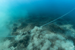
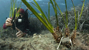
Boat anchors and chains leave irreversible scars on Posidonia meadows and this impact intensifies with the size of the boat.
The DONIA application allows you to :
- Choose your anchorage outside sensitive ecosystems (seagrass beds, coralligenous reefs); – View local regulations and share your observations;
- Display multiple information on land and at sea (diving sites, ports, dangers, underwater photos, points of interest, etc.);
- Consult the positions of boats in real time, with the possibility of finding your friends
- View weather forecasts and anchorage areas coupled with the weather forecast for more safety and eco-responsibility, AIS (Automatic Identification System) data, navigation tools (prediction arrow, waypoints and measurement tools, navigation routes), a skid, entanglement and collision alarm pack for more safety at sea
- Access advanced data and features such as high definition bathymetric charts, SHOM charts (Service Hydrographique et Océanographique de la Marine)
A manager module, DONIA Manager, is added to the application. It allows managers to interact with their visitors and to help them fulfil their mission of providing information and planning uses (it will not be detailed in this guide dedicated solely to the platform’s projects).
Directly on the platform, by clicking on “Access the maps“, you can access the simplified habitat mapping in four classes and limited to the surface portion – 50 m depth is available along the French Mediterranean coasts, in the Liguria region and some Small Mediterranean Islands (cf. PIM project): the Archipelago of Galite and the island of Zembra (North of Tunisia) and the island of Tavolara (North-East of Sardinia). You can display on the map, independently of the biocenoses, the isobaths (up to 50 meters depth), the marine regulation data and points of interest.
Contacts : Agathe Blandin/ Gwenaëlle Delaruelle / Jo-Ann Schies
Project Leader : Andromède Océanologie – www.andromede-ocean.com
With the contribution of the following structures, for the biocenosis data: AMP de la côte Agathoise; Andromède Océanologie; Agence de l’Eau Rhône-Méditerranée et Corse; Area Marina Protetta Capo Carbonara; Area Marina Protetta Tavolara; ASCONIT Consultants; Association Œil d’Andromède; COMEX-SA; Communauté de communes du Golfe de St Tropez; Compilation OFB, 2019 according to data Seaviews/Biotope – AFB 2018 and Andromède Océanologie (SHOM, IGN, AAMP, Fugro, Andromède Océanologie)- DIREN LR 2008 – AAMP 2012; Conservatoire du Littoral; Créocéan; DREAL PACA; EGIS EAU; EPHE de Perpignan (2014); ERAMM; EVEMAR; Expedition Gombessa 5; GIS POSIDONIE; Hellenic Centre for Marine Research; IFREMER; Institut Balear de la Natura; Institut océanographique Paul Ricard; IN VIVO; Nice Côte d’Azur; Parc Marin International des Bouches de Bonifacio; Pasqualini; Programme CARTHAM – Agence des Aires Marines Protégées; MEDBENTH Programme; SURFSTAT Programme; Sintinelle; Stareso; Liguria Region; Toulon Provence Méditerranée; University of Corsica (EQEL); Ville d’Agde; Ville de St Cyr sur mer; Ville de Cannes; Ville de Marseille; Ville de St Raphaël; Ville de St Tropez; P2A Développement; SubC-MARINE; OFB-PNMGL
Update frequency: Annual for the project; 1 to 6 years depending on the sector for the mapping.
Last update of the cartography: June 2022.
Partners: Rhône Méditerranée and Corse Water Agency, NAOS.
Associated scientific publications
• Mapping biodiversity in three-dimensions challenges marine conservation strategies (Doxa et al., 2015)
• Impact of 85 years of coastal development on seagrass beds (Holon et al., 2015a)
• Fine-Scale Cartography of Human Impacts along French Mediterranean Coasts (Holon et al., 2015b)
• A predictive approach to benthic marine habitat mapping (Vassallo et al., 2018)