NETWORK FOR SURFACE ANALYSIS OF MARINE HABITATS
Created in 2013, the SURFSTAT network is part of the biology component of the WFD network. Its main objective is to assess, using a statistical approach, the ecological heterogeneity of the seabed in space and time between 0 and 80 m depth on the French Mediterranean coast. The description of the heterogeneity is essential to assess the fragmentation and connectivity of habitats.
The first mission of this network is to complete the existing 2D underwater habitat mapping (realization and study of geographical maps) and to establish the 3D correspondence of marine habitats. The second is to propose and measure different composition and configuration variables that can be used as surface (= spatial) indicators of coastal water quality from these marine habitat maps. SURFSTAT is thus a first step towards a large-scale monitoring tool (with interpretation grid) of marine habitats.
The SURFSTAT project presents the main results of the surface analysis applied to the Posidonia seagrass habitat:
- A map of the global evolution of the Posidonia meadow. It combines the evolutions at the lower and upper limits (comparisons made with old aerial photographs dating from the 1920s between 0 and 15 meters (Andromeda Oceanology, 2013 ; Holon et al., 2015)). All areas where the state of the meadow was qualified as regressive based on the comparison with old aerial photographs between 0 and 15 meters were mapped as dead matte on this evolution map. In the PACA region, the MEDBENTH database (RMC Water Agency / IFREMER) and the CARTHAM program (AAMP/MEEDTL) have made it possible to map 70% of the coastline to a depth of about 60 meters. In order to have reliable cartographic data, field campaigns were carried out to complete and update these data.
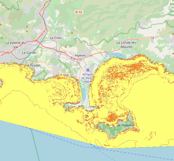
- A cartographic representation (according to a grid of pixels of 50 x 50 meters) of the regression index of the Posidonia meadow. It corresponds to the current surface of the dead mat (former and current) over the sum of the surface of the dead mat (former and current) and the current surface of the Posidonia meadow.
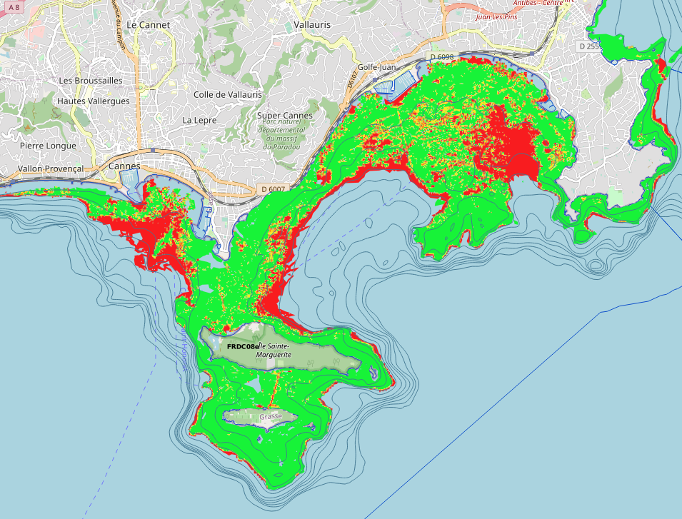
Cartographic representation (according to a grid of pixels of 20 x 20 meters) of the regression index of the Posidonia meadow in the Gulf of Juan (Antibes).
- A cartographic representation (according to a 50 x 50 meter pixel grid) of Simpson’s diversity index. This index is calculated as follows : D = ∑ Ni(Ni-1)/N(N-1)
D : Simpson’s index
Ni : area of a given habitat on a 50m² pixel.
N : total area of habitats.
➔ The index varies between 0 and 1. The closer it is to 0, the higher the chance of different habitats.
Cartographic representation (according to a pixel grid of 50 x 50 meters) of the Simpson diversity index in the Rade d’Hyères.
- A cartographic representation of the distribution of the Posidonia meadow. According to the environmental variables and the cohesion index. Data published by Fabrice Houngnandan in his article : Identification of conservation areas for Posidonia meadows, Biological Conservation (Houngnandan et al., 2020).
Comparison tool on the Medtrix platform.
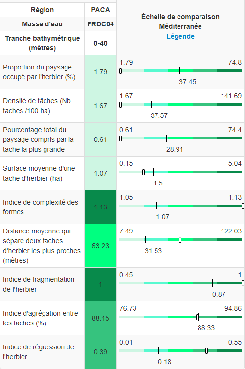
By clicking directly on the button “Access the maps“, just below, you will find all the results of this project since 2013, as well as a comparison tool that allows you to compare a dozen indices (not represented on medtrix) from the analysis of biocenoses conducted under the software R and this at different spatial scales of comparison (Mediterranean, Region, coastal water body). The ‘seagrass’ indices concern only Posidonia meadows (0-40m) and the ‘landscape’ indices take into account all habitats (priority habitats : seagrass and coralligenous & all others detailed in the DONIA EXPERT project ; 0-60m).
Contact : Gwenaëlle Delaruelle/ Agathe Blandin
Porteur du projet : Andromède Océanologie
Fréquence d’actualisation : Tous les deux ans
Dernière actualisation de la cartographie : Mai 2021.
Partenaire : Agence de l’eau Rhône Méditerranée et Corse
Study reports